Overview:
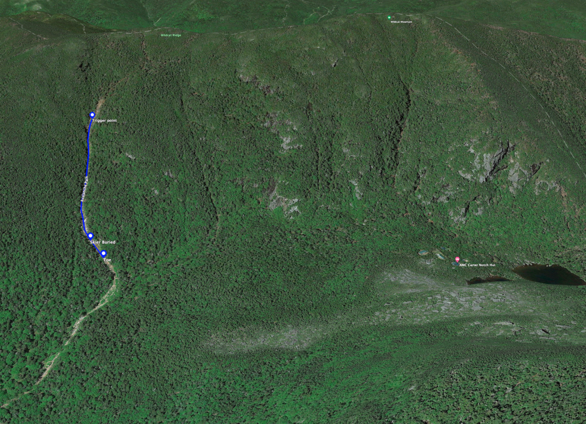
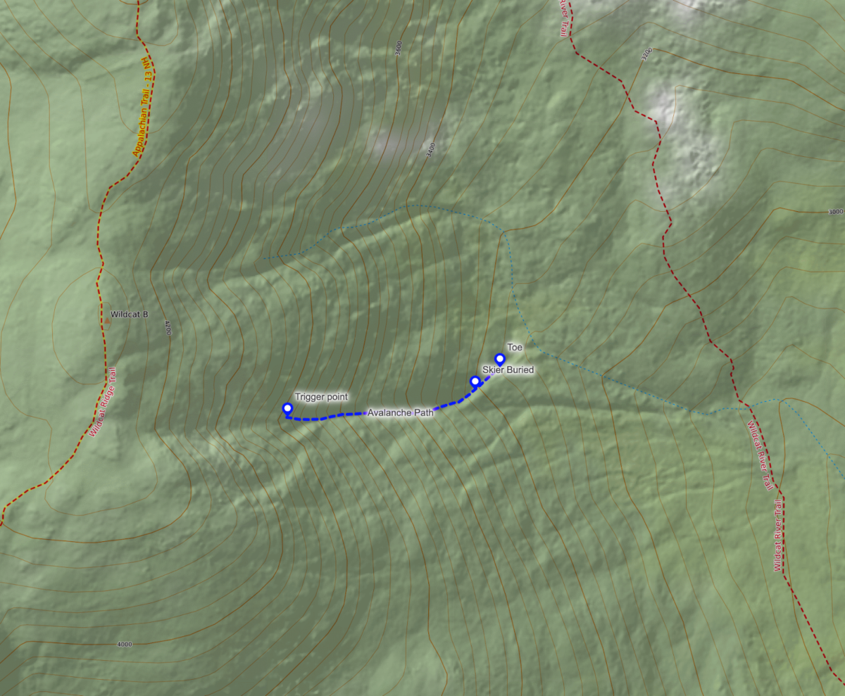
On Wednesday, March 15th 2023 at approximately 10:00 am, a skier unintentionally triggered a large avalanche on Wildcat B in Carter Notch. They were caught, carried, and critically buried for over 6 minutes before being extracted by a partner and found uninjured. The party of two was able to self-evacuate from the incident. This avalanche path is just 2.5 miles away from the Mount Washington Avalanche Center Presidential Range forecast area. The avalanche danger for the Presidential Range was rated HIGH at middle and upper elevations.
Accident Summary:
Early in the morning on March 15th, three skiers (Skier A, Skier B, and Skier C) ascended Wildcat Ski Area with the intent of continuing across Wildcat Ridge Trail to access a landslide terrain feature on the east side of Wildcat B in Carter Notch. At the top of Wildcat Ski Area, before continuing to the hiking trail, Skier A accessed the updated MWAC avalanche forecast and read the forecast aloud to the group. Skier A felt that the objective was too risky given the conditions and decided not to continue. Skier A encouraged Skier B and Skier C to reconsider the objective and descend Wildcat Ski Area as a safe alternative. Skier B and Skier C made the decision to continue on the ridge trail to Wildcat B to access the original objective without Skier A. Before splitting up, Skier A loaned their avalanche beacon to Skier B who forgot this piece of rescue equipment. At that point, Skiers B and C both had an avalanche rescue kit: beacon, shovel, and probe.
Once at the top of the intended ski objective, Skiers B and C decided to continue and ski one-at-a-time. Skier C began descending and triggered a large soft slab avalanche at the steepest part of the slope, in an area where a steep ice bulge often forms. They were caught in the moving debris and carried over 500 vertical feet down a narrow, constricting gully. They came to rest fully buried, except for their hand, and were trapped and unable to move under the avalanche debris.
Skier B took out the borrowed avalanche beacon and began a search for their missing partner descending the track of the avalanche. They did not acquire a signal. The reason for not acquiring a signal is unknown. As they approached the debris, they noticed Skier C’s hand visible above the surface of the snow. This clue allowed them to quickly pinpoint their partner’s location and begin digging. Skier B was able to successfully extract their buried partner, who was conscious and not injured. Skier C was completely buried for a total of 6.5 minutes, when Skier B uncovered and secured their airway. After a total of about 15 minutes, Skier C was fully extracted.
Avalanche Summary:
Type: Soft Slab
Trigger: Skier, unintentional
Aspect: East
Slope Angle: 42 degrees
Size: R5 / D2
Elevation: 3750 feet
Sliding Surface: New / Old Interface
Vertical Fall: 550 feet
Width: 50 feet
Crown Depth: 12 inches
Debris Depth: 9 feet
The slope where this avalanche occurred was formed by a summer-time landslide which cleared trees and earth in the main part of the drainage. This event from many years ago created a terrain feature that collects significant amounts of snow and is vulnerable to avalanche hazard. The east-facing slope has a tubular characteristic and is generally very narrow. The top of the avalanche path is at an elevation of 3800’ and the bottom of the runout is at an elevation of approximately 3000’. The starting zone of this terrain feature is generally 50 – 60 feet across with an average slope angle of 41 degrees and a maximum slope angle of about 50 degrees. The track of the path is about 25 feet across with an average slope angle of 42 degrees. The runout zone widens slightly, but is still a halfpipe-shaped slope, which compounds the depth of avalanche debris. The approximate depth of avalanche debris in this incident was 9 feet.
Backcountry Avalanche Forecast:
*Though this incident occurred outside the Presidential Range forecast area, it is important to note that avalanches can happen when snow falls on any steep terrain over 30 degrees. This area shares many of the same characteristics of avalanche paths just 2.5 miles away included in the forecast area.*
The Mount Washington Avalanche Center forecast on March 15, 2023, rated the avalanche danger in the Presidential Range at HIGH above 3,000 feet in elevation on all aspects. Wind slab avalanches were highlighted as the primary avalanche problem on all aspects and elevations with loose dry avalanches highlighted on all elevations and aspects below treeline. The expected size of wind slabs was small to very large (D1-3) and likely to be triggered naturally or from the weight of a person. Loose dry avalanches were listed as possible, and generally small in size (D1 – D1.5). The Bottom Line section of the forecast stated:
Natural and human triggered avalanches are likely on all aspects and elevations. Moving through, under, or adjacent to steep terrain will be dangerous today with avoidance being the best strategy.
A link to the full avalanche forecast from March 15 can be found here.
Weather and Snowpack Summary:
Prior to the 3/13 – 3/15 storm, several days of high pressure, high winds, and mild temperatures had created a generally stable snowpack that was firm in most places. Between Monday, March 13th and Wednesday, March 15, the Mount Washington Observatory recorded 13.5 inches of new snow, the Hermit Lake snow plot recorded 23 inches of new snow, and the Harvard Cabin snow plot recorded 19 inches of new snow.
On the 13th, the avalanche danger was rated LOW; on March 14th, the avalanche hazard was rated CONSIDERABLE; on March 15th, the avalanche danger was rated HIGH. This increasing trend was consistent with the onset of snow storm conditions and subsequent redistribution of snow by high wind speeds.
New snow beginning on the 13th fell on relatively light winds from the southeast before shifting to the north and northwest on the 14th and 15th. This combination created new wind slabs on many aspects with significant redistribution of snow to southerly and easterly aspects once the winds shifted. Summit winds had an average speed of 57 mph on the 14th and 51 mph on the 15th. Average wind direction was north. New wind slab depth was variable but was able to grow multiple feet in many areas and displayed strong-over-weak characteristics. These slabs with weak structure were resting on an old snow surface that was firm and scoured in many locations. The hardness change of this new/old interface, the depth of new snow, and the strong-over-weak structure of new slabs were the dominant contributing factors in this avalanche.
Comments:
One of the main reasons we share details about avalanche accidents is for education and awareness for the greater community with the hopes of becoming collectively safer. In return for sharing this information, we ask that any comments are civil, non-judgmental, and constructive.
The outcome of this event had serious potential to be fatal and the Mount Washington Avalanche Center staff is happy that the group of two skiers skied away from this event uninjured and hopefully learned several important lessons.
- Avalanches can occur in any terrain where snow with a weak layer, a steep slope, and a trigger are present, even if that terrain is outside of a designated avalanche forecast area. Recognizing this terrain takes knowledge and skill and taking an avalanche course is a great place to begin to build that foundation.
- Always have rescue gear that is familiar to you and that you have practiced with if entering avalanche terrain. Don’t forget a proper beacon function check before entering avalanche terrain. Like in this incident, you or your partner’s life may depend on it.
- Listen to every member of your group when making decisions. Fully talk through objections or differences of opinion when making go/no-go decisions. Consider heuristic traps that tempt you to make decisions that may put the lives of you and your partners at risk.
- Read and apply the avalanche forecast to your terrain choices. On a HIGH danger day, safe terrain options are extremely limited and “outsmarting” the avalanche problem is like rolling loaded dice.